


falaises des andelys

olivieraron
User
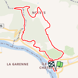

Length
9.9 km

Max alt
151 m

Uphill gradient
319 m
Km-Effort
14.2 km

Min alt
7 m

Downhill gradient
318 m
Boucle
Yes
Creation date :
2019-01-14 09:41:32.678
Updated on :
2019-01-14 09:41:32.703
2h00
Difficulty : Unknown

FREE GPS app for hiking
 SityTrail
IGN / Geographical institutes
SityTrail Plus
The world is yours!
About
Trail Other activity of 9.9 km to be discovered at Normandy, Eure, Les Andelys. This trail is proposed by olivieraron.
Positioning
Country:
France
Region :
Normandy
Department/Province :
Eure
Municipality :
Les Andelys
Location:
Unknown
Start:(Dec)
Start:(UTM)
383505 ; 5455587 (31U) N.
Comments